
Dickson Mounds
USA / ILLINOIS / MISSISSIPPIAN
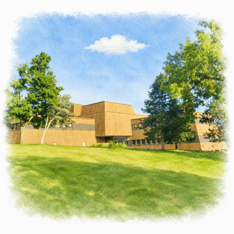
On a bluff above the Illinois River floodplain, Dickson Mounds centers on a museum shaped by excavation, public display, and changing interpretation, making the treatment of the site part of its identity.
| Name | Dickson Mounds |
|---|---|
| Civilization | Late Woodland and Mississippian |
| Location | Fulton County, Illinois, United States |
| Elevation | Approximately 545 feet (166 meters) |
| Years Active | c. 800 to 1250 CE |
| Primary Resources | Maize, fish, deer, wild plants, freshwater mussels, and timber |
| Site Type | Burial mound, cemetery, village, and archaeological museum complex |
| Key Highlights | Museum river valley exhibits, Eveland structures, observation deck |
| INT Airport | General Wayne A. Downing Peoria International Airport (PIA) |
| Entry Fee | Free |
| Best Time to Visit | Tuesday through Saturday, spring through fall |
| Field Visit | Visited & photographed by Lost Ruins of the Americas |
Unique Features of Dickson Mounds Archaeological Site
- Overlapping Cemetery: Two cemeteries and ten overlapping mounds formed the bluff-top burial complex.
- Bluff-Hugging Museum: The 1972 building follows the low contours of surrounding earthworks.
- Eveland Structures: Three excavated Mississippian ceremonial buildings remain preserved outdoors.
- River Valley Galleries: Exhibits trace 12,000 years of Indigenous life in the Illinois River Valley.
- Evolving Interpretation: Tribal consultation has reshaped how burials and regional history are presented.
Location & Access
- Nearest Town: Lewistown, Illinois, approximately 4 miles
- Directions: From Lewistown, follow Fulton County Highway 9 southeast, turn left onto North Dickson Mounds Road, and follow the entrance signs to the museum.
- Official Site Authority: Illinois State Museum, Dickson Mounds
- Opening Hours: Tuesday through Saturday, 9:00 AM to 4:30 PM.
- Entry Fees: Free admission.
- Facilities: Museum galleries, observation deck, accessible restrooms, picnic shelter, playground, restored prairie, seasonal outdoor exhibits, and approximately four miles of trails.
- Accessibility: The museum is accessible, with wheelchairs and sensory kits available. Outdoor trails include uneven natural surfaces.
- Pro Tip: Set aside time for the Eveland Village excavations, where the preserved remains of three early Indigenous buildings can be viewed beneath protective coverings during the warmer months.
Highlights to Help Understand Your Visit
Dickson Mounds is best understood as a layered archaeological landscape rather than a park filled with obvious standing ruins.
- Look Beyond the Museum: Burial mounds, villages, ceremonial buildings, and older Hopewell remains once spread across the bluff and the river terrace below.
- Notice What Is Hard to See: The Dickson burial complex contains two cemeteries and ten overlapping mounds, but most now blend into the natural slopes.
- Follow the Changing Landscape: Middle Woodland, Late Woodland, and Mississippian communities used this area at different times, leaving several layers of settlement and ceremony.
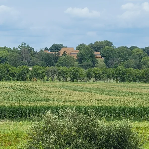
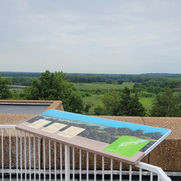
- Use the Bluff View: From the museum grounds, the broad Illinois River Valley helps explain why communities repeatedly built villages and ceremonial centers here.
Key Structures of Dickson Mounds
Dickson Mounds is not a single group of earthworks. The museum stands within a much larger archaeological landscape of burial mounds, villages, ceremonial buildings, and an older Hopewell center spread across the bluff and the river terrace below.
- Dickson Mounds Museum: The modern museum stands within the archaeological site and contains more than 15,000 square feet of exhibits exploring Indigenous life, archaeology, and the changing environment of the Illinois River Valley. Its hilltop setting also provides broad views across a valley once filled with villages, mounds, and ceremonial centers.
- Dickson Burial Complex: Two cemeteries and ten overlapping burial mounds occupy the bluff beneath and around the museum. They once surrounded a low mound that may have supported a building used during burial ceremonies, but the earthworks now merge into the natural slopes and are difficult to distinguish.
- Myer-Dickson Village: A large Mississippian settlement once occupied the level ground north of the museum. The village included an open plaza and an approximately 80-foot-long ceremonial building near the present parking area.
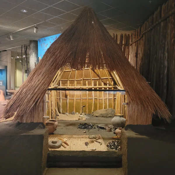
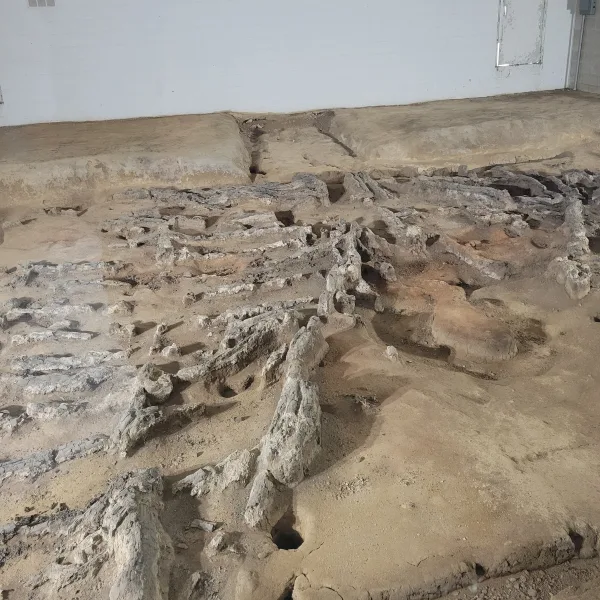
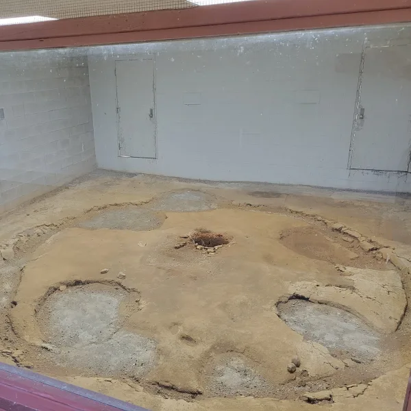
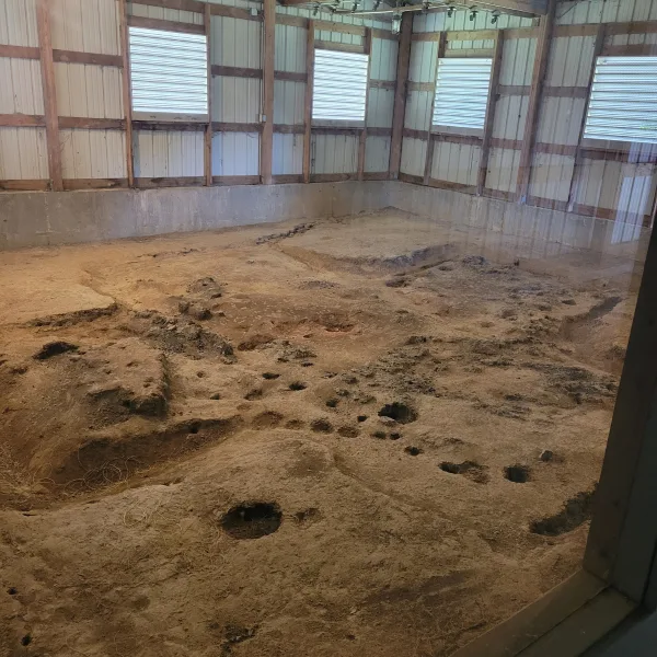
- Eveland Village Buildings: The excavated remains of three ceremonial buildings are preserved for viewing during the warmer months. The structures have round, cross-shaped, and large rectangular plans, and the site may have served as a ceremonial center for nearby Mississippian communities around 1100 CE.
- Ogden-Fettie Mound Group: On the lower terrace south of the museum, a much older Havana Hopewell community built about thirty burial mounds beside an extensive village. The great Ogden Mound still survives as a visible reminder of this 2,000-year-old community.
History and Legends
The bluff carrying Dickson Mounds rises above the broad wetlands of the Illinois River valley, within sight of the country around the Spoon River confluence. Late Woodland families occupied this high ground by about 1,500 years ago. Their settlement, now called Myer-Dickson, included houses, storage pits, and work areas positioned close to rich fishing, hunting, gathering, and farming grounds below. Over time, the bluff also became a burial place, beginning a sequence of construction and interment that continued for several centuries.
During the eleventh century, Mississippian architecture, pottery, farming practices, and political connections spread through the central Illinois River valley. These changes were closely tied to the expanding influence of Cahokia farther south, but communities around Dickson Mounds developed their own regional centers. At Eveland Village, below the burial bluff, people erected an unusual group of public buildings around AD 1100. Excavation revealed round, cross-shaped, and rectangular structures, three of which remain sheltered on the museum grounds. The complex may have served nearby farmsteads and small settlements that lacked large ceremonial buildings of their own.
Above Eveland, generations continued to bring their dead to Dickson Mounds. The burial ground eventually contained two cemeteries and ten low mounds whose edges overlapped, arranged around a smaller platform that probably supported a building used during burial ceremonies. About 250 early twelfth-century burials have been identified in the Mississippian portion of the complex. Copper ornaments, marine-shell beads, decorated pottery, stone tools, and other objects placed with some of the dead connect the bluff to exchange networks extending well beyond the Illinois Valley. Much of the mound complex remains unexcavated, and many of its low earthworks now merge almost imperceptibly with the natural slope.
Experiences Around Dickson Mounds
Wooded bluffs and broad wetlands spread along the Illinois River, with restored floodplain lakes below the museum.
–
Emiquon National Wildlife Refuge opens across shallow lakes and marshes used by pelicans, herons, and migrating waterfowl.
–
In Lewistown, follow the self-guided route through Oak Hill Cemetery, where graves of local residents are linked to characters in Edgar Lee Masters’s Spoon River Anthology.
The living settlement on the bluff also expanded. North of the present museum, Mississippian residents laid out an open plaza beside houses and a public building roughly 80 feet long, among the largest known Mississippian structures in Illinois. During the thirteenth century, warfare and political change drew many people in the central Illinois River valley into compact, palisaded towns. The nearby Larson site became a stockaded regional center around AD 1250, while burial activity at Dickson Mounds gradually diminished. Few people were interred there after about 1300, marking a shift in how communities organized both their towns and their burial places, not the disappearance of Native peoples from the region.
Don Dickson began excavating the mounds on his family farm in 1927, removing the soil while leaving hundreds of Native ancestors exposed in their graves. First sheltered beneath a tent and later enclosed within a private museum, the burial display drew tens of thousands of visitors. Illinois purchased the property in 1945, and the present museum opened in 1972 with the excavation still on view. By the late twentieth century, Native advocates and people within the museum system were pressing for a different approach, even as the proposed changes met strong local resistance. After the burial exhibit closed in 1992, Dickson Mounds began the difficult work of reconsidering how the site and the people buried there should be presented. That work has continued through consultation with Tribal Nations, repatriation, revised exhibits, and a growing recognition that those beneath the museum are ancestors connected to living communities. Changing an institution so closely identified with a famous burial display has not been simple, and the process remains unfinished. Dickson Mounds deserves credit for confronting that history directly and becoming an important example of how archaeological museums can change toward a more respectful and responsible interpretation of Native history.
Dickson Mounds Museum
Dickson Mounds Museum contains more than 15,000 square feet of exhibition space exploring Indigenous life, archaeology, and the changing environment of the Illinois River Valley. The River Valley Gallery follows the relationship between people and the river from the end of the Ice Age to the present, using exhibits, photographs, video, and an observation deck overlooking the valley. Other displays use artifacts, murals, reconstructed settings, and hands-on elements to connect the surrounding archaeological sites with the communities that lived here over thousands of years.
The museum also includes rotating exhibitions and the Discovery Center, with family activities, discovery drawers, books, videos, and an indoor playscape. Because some galleries are being reviewed or revised, the exact exhibitions may change between visits. The museum remains open as a place to understand the wider Indigenous and environmental history of the Illinois River Valley, not only the burial site beneath the building.
Outside, the museum grounds extend across approximately 230 acres. Visitors can see the sheltered remains of three early Indigenous buildings at Eveland Village during the warmer months, walk through restored prairie, use the picnic grounds and playground, and look across the floodplain toward the restored Emiquon wetlands. Together, the museum and surrounding archaeological landscape allow visitors to encounter the history through both exhibits and the ground where it happened.
Why the Burial Exhibit Closed
For decades, visitors entered a gallery built around exposed Native American graves. By 1990, museum officials and Indigenous advocates were pressing for the burials to be removed from public view. Many local residents opposed the change, seeing the exhibit as an educational landmark and an important part of the regional economy. Indigenous protesters answered that the people below the museum were ancestors, not objects for display. The dispute brought demonstrations, public meetings, police presence, and a difficult reassessment of what respectful interpretation should require.
The debate unfolded during a national change in the treatment of Indigenous remains. President George H. W. Bush signed the Native American Graves Protection and Repatriation Act on November 16, 1990, establishing a federal process for returning Native American ancestors and cultural items to affiliated communities. After negotiations under Governor Jim Edgar, Illinois announced that the Dickson burial exhibit would close. The graves were covered from public view on April 3, 1992, while the museum began moving toward interpretation shaped by consultation, dignity, and respect. NAGPRA did not itself order the Dickson closure, but it formed part of the wider change that made the old display increasingly unacceptable.
How to Get There & Where to Go Next
How to Visit Dickson Mounds
Step-by-step access to the site
- Arrival Airport: Fly into General Wayne A. Downing Peoria International Airport.
- Drive to Lewistown: Follow the US-24 corridor toward Lewistown, allowing approximately one hour.
- Turn South: From Lewistown, take Illinois Route 78/97 south toward the museum.
- Final Approach: Follow signs onto North Dickson Mounds Road and continue to the main parking area.
- Begin Indoors: Start with the museum galleries before visiting the observation deck, outdoor structures, and trails.
Tip: Check the museum calendar before traveling, since outdoor exhibits and special programs may operate seasonally.
Nearby Ruins You Can Visit
The lower Illinois River Valley contains mound groups and ceremonial landscapes from several periods of Indigenous history.

Rockwell Mound: A broad Havana Hopewell earthwork in Havana covering nearly two acres and standing approximately 14 feet high.

Toolesboro Mounds: Seven protected Hopewell burial mounds and a small museum preserve another river-centered ceremonial landscape in southeastern Iowa.

Ogden-Fettie Mounds: A short drive from the museum leads to a 15-foot Hopewell mound and the remnants of a thirty-mound cemetery.
Traveler Tips
- What to Bring: Water, walking shoes, insect repellent, and weather protection for the outdoor grounds.
- Best Time to Visit: Spring and fall offer comfortable trail conditions, while summer brings full wetland and prairie growth.
- Visit Length: Allow two to three hours for the galleries, observation deck, and a portion of the trails.
- Trail Conditions: Outdoor routes include grass, woodland paths, slopes, and potentially muddy surfaces after rain.
Elsewhere in the Americas…
While Cahokia rose in the North American floodplains, other cultures across the Americas were reaching new heights of power and influence:


In northern Peru, Kuélap expanded behind massive stone walls as a Chachapoya political and ceremonial center.

In Colombia’s Sierra Nevada, Ciudad Perdida linked terraces, plazas, stairways, and roads across a mountain settlement.
Insider Explorer Advice
Approaching from historic Havana, the route crosses the Scott W. Lucas Bridge and follows the Emiquon floodplain wetlands before climbing toward the bluff. The museum appears suddenly as a low, angular work of late-modernist architecture. Its sloping, terraced profile echoes the mound forms and seems to settle into the hillside rather than stand apart from it.
The current exhibits are well laid out and give a clear account of the valley’s long Indigenous history, but the museum’s own recent history deserves equal attention. Dickson Mounds moved from a private roadside attraction to a state museum, then became a focus of Indigenous protest and institutional change. The present interpretation does not hide that evolution. It demonstrates that access to the past and respect for Indigenous communities are not opposing goals, and that public archaeology becomes stronger when curiosity is joined by consent, consultation, and accountability.
Summary: Dickson Mounds preserves a burial landscape, a river-valley story, and a museum whose changing interpretation is now part of the history it presents.