
Xlapak
MEXICO / YUCATAN / MAYA
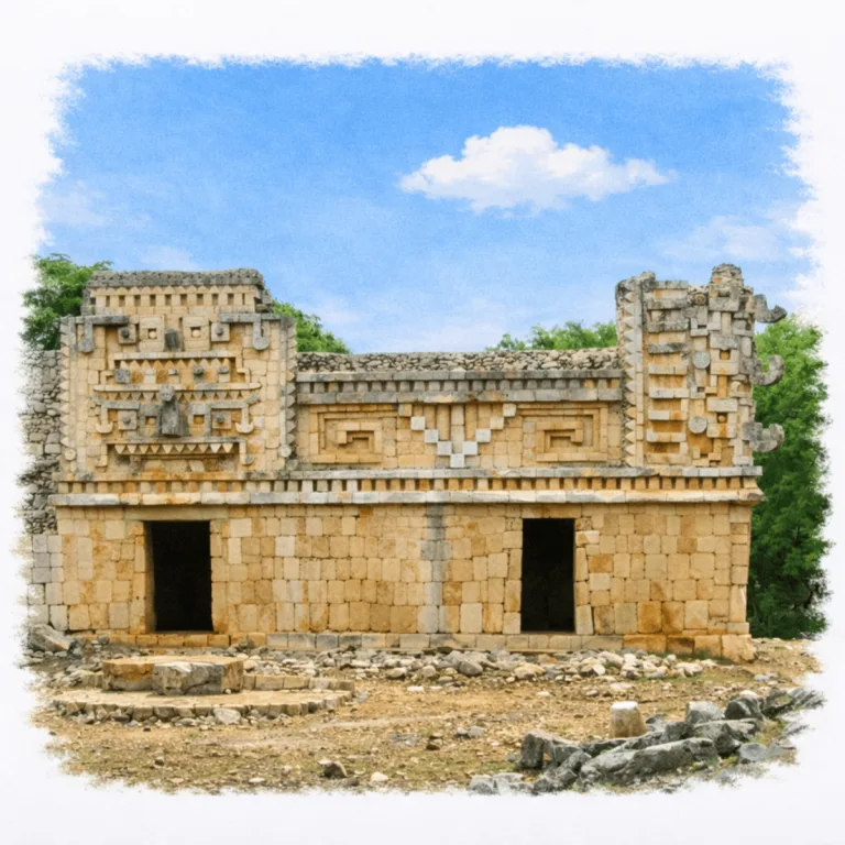
In a shallow valley between the Puuc hills, Xlapak gathers decorated palace façades, where stacked Chaac masks and mosaic stonework give this small Maya site an outsized architectural presence.
| Name | Xlapak |
| Civilization | Maya |
| Location | Puuc Route, Yucatán, Mexico |
| Elevation | 100 m (28 ft) above sea level |
| Years Active | c. 600 – 1000 CE |
| Primary Resources | Limestone, stored rainwater, agricultural goods, honey, cotton |
| Site Type | Agricultural settlement and elite residential center |
| Key Highlights | The Palace, Puuc mosaics, Chaac masks, compact valley setting |
| INT Airport: | Mérida International Airport (MID) |
| UNESCO | Part of the Uxmal regional inscription (1996) |
| Entry Fee | 75 MXN (~4 USD) |
| Best Time to Visit | Late morning or early afternoon (least crowded) |
| Field Visit | Visited and documented by Lost Ruins of the Americas |
Unique Features of the Xlapak Archaeological Site
- Compact Valley Setting: A small Puuc center surrounded by fertile low hills.
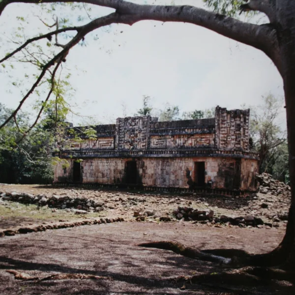
- El Palacio: Finely fitted mosaics carry Xlapak’s strongest architectural detail.
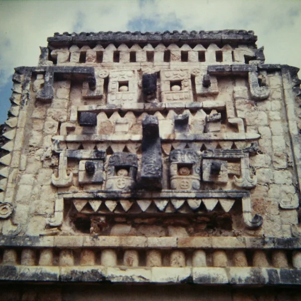
- Chaac Mask Façade: Repeated rain-deity masks dominate the Palace decoration.
- Agricultural Role: Productive fields supplied Xlapak and larger neighboring cities.
- Human-Scale Ruins: Modest buildings keep Puuc craftsmanship close and clearly visible.
Location & Access
- Nearest Town: Santa Elena, Yucatán
- Directions: From Mérida, follow Federal Highway 261 south through Muna and Santa Elena. At kilometer 105, turn onto the Ruta Puuc road and continue approximately 10 kilometers to Xlapak. The site lies about 113 kilometers from Mérida.
- Official Website: INAH Zona Arqueológica de Xlapak
- Opening Hours: Monday to Sunday, 8:00 AM to 4:00 PM
- Entry Fee: 80 MXN; 145 MXN for foreign visitors
- Facilities: Entrance parking and basic visitor services; No museum, shops, or infrastructure on site
- Accessibility: Limited. The route is compact, but uneven limestone, roots, and low steps restrict wheelchair access.
- Puuc Route Sites: Uxmal, Kabah, Sayil, Labná
- Pro Tip: Visit Xlapak before the final stop of the circuit. It closes at 4:00 PM, one hour earlier than nearby Labná.
Highlights to Help Understand Your Visit
Xlapak may be small, but it reveals deep insights into Maya space, symbolism, and regional connectivity. These notes will help you read the site with sharper eyes:
- Reading Without Signs – Xlapak has no interpretive panels. Every detail must be read from stone: the layout, the ornamentation, the silence of the setting.
- Elevation Equals Importance – The Palace of the Masks stands on a raised platform. Even a modest step up signaled sacred status in Maya design.
- Hidden Infrastructure – Look for circular stone caps or depressions — these mark ancient cisterns (chultunes), key to survival in the dry Puuc hills.
- Intentional Orientation – The building faces northward, possibly aligned with other nearby centers. This wasn’t random — it was cosmological.
- Fragments Tell Stories – Fallen cornice stones and mask pieces lie around the site. These are not rubble — they are displaced records of symbolic meaning.
Key Structures of the Xlapak Ruins
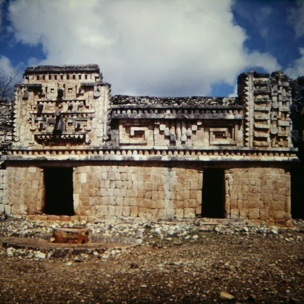
- Palace of the Masks – Xlapak’s most iconic structure, this small yet finely constructed building showcases classic Puuc architecture. Its upper façade is covered in a dramatic sequence of stacked Chac masks, with curling stone noses and lattice-style mosaic patterns in between. The symmetry and preservation of the decoration are among the best along the Puuc Route. Though modest in scale, the artistry makes it a standout example of regional stonework.
- Rear Platform Complex – Behind the main palace lies a partially collapsed platform with low walls and rubble mounds, believed to be the remains of secondary ceremonial or residential spaces. Some stones still show traces of decorative molding, though nature has largely reclaimed the area.
- Northwestern Structures – On the forested edge of the site are additional stone bases and minor ruins, including what may have been storage areas or ancillary rooms. These are less defined but hint at a more complex settlement than the main plaza alone suggests.
- Stone Pathway and Site Clearing – A short walking path leads into the site from the road, curving gently toward the palace through shaded forest. This entryway likely follows the route of an original sacbé (ceremonial white road), now overgrown but still guiding visitors to the heart of the complex.
History and Legends
Xlapak was a small ceremonial center active between 600 and 900 CE, during the height of the Puuc architectural tradition in the northern Maya lowlandsn are now called the Puuc Route. Its name, meaning “Old Walls” in Yucatec Maya, is modern; the original name of the settlement is unknown. Though far less developed than nearby Uxmal or Kabah, Xlapak reflects the same skilled craftsmanship and symbolic design seen throughout the region.
The site’s main structure, known as the Palace of the Masks, features a carefully built façade of stone mosaic panels and projecting Chac masks. This building style places Xlapak firmly within the Terminal Classic period, when smaller ceremonial centers were linked by road networks to larger cities. No hieroglyphic inscriptions have been found here, which leaves many questions unanswered about the site’s rulers or rituals.
Archaeologists believe Xlapak may have served as a satellite or checkpoint along a sacbé connecting Sayil and Labná. Its modest size, strategic location, and presence of chultunes suggest it played a support role in the Puuc landscape. The design of the central structure shows planning and symmetry, indicating local importance even without monumental scale.
Experiences Around Xlapak
The ruins are only part of the story. Low limestone hills and orchard country spread across the Puuc, where fertile soils sit above a landscape with almost no surface water.
–
In Oxkutzcab, browse the 20 de Noviembre market, piled with citrus, tropical fruit, vegetables, and stalls serving Yucatecan breakfasts.
–
Farther south, descend into the Grutas de Loltún, where limestone galleries preserve rock paintings, carvings, and evidence of thousands of years of human use.
Like many Puuc ruins, Xlapak was first brought to wider attention by 19th-century explorers including John Lloyd Stephens and Frederick Catherwood. However, it received minimal restoration, which has ironically preserved its atmosphere. Today, INAH maintains the site, but it remains minimally developed, a quiet enclave lost to jungle and time.
How to Get There & Where to Go Next
How to Visit Xlapak
– Step-by-step access to the site –
- Take Tren Maya to Mérida – Approx. 5.5 hours.
- Travel south by car – Drive from Mérida to Xlapak via Muna and Santa Elena (2 hours).
- Follow the Puuc Route – Exit onto the signed access road between Sayil and Labná (10 minutes off main highway).
- Park near the trailhead – Small gravel turnout with basic signage and room for a few vehicles.
Tips: Xlapak is free to enter and rarely staffed. Combine with Sayil and Labná for an efficient loop.
Nearby Ruins You Can Visit
The Puuc Route links Kabah to other ceremonial sites through ancient roads, shared iconography, and regional alliances shaped by both ritual and rivalry.

Kabah – Known for the Codz Poop, a façade covered in over 250 Chac masks stacked in dramatic rows.

Uxmal – A dominant Puuc capital of towering pyramids, palace quadrangles, and precise cosmological alignments.

Labná – Intricate archways, columned halls, and fine Puuc latticework carved deep in the forest.
Traveler Tips
- Ask about a Puuc Route combo ticket at your first stop. Multi-site access is sometimes available but not always advertised
- No restrooms or vendors, bring water, snacks, and insect repellent.
- The site is small and walkable in 30–45 minutes. A perfect pause between Sayil and Labná.
- Minimal signage, bring a guidebook or offline notes if you’re interested in architectural details.
- Paths are shaded but can be slippery after rain, wear sturdy shoes.
Elsewhere in the Americas…
While Xlapak developed its ceremonial center in the Puuc hills, monumental sites across the Americas reflected rising empires and shifting coastal power:


Batán Grande and nearby sites marked the rise of early Sicán rule, as new religious centers began replacing older Moche strongholds.

In the Andes, the Chachapoya center of Kuélap developed massive stone walls and circular structures across a fortified mountaintop.
Insider Explorer Advice
Xlapak was part of a full-day loop of the Puuc Route from Mérida that included Sayil, Labná, Kabah, Xlapak, and Uxmal. Unless you have a car or hire a private driver, this is the most practical way to experience the route. Tours come in all styles, but it’s worth seeking out an informal, mostly local tour departing from Mérida, typically with a small bus, a single guide or coordinator, and light commentary at each stop. Each site on the loop had its own atmosphere, but Xlapak stood out. No vendors. No crowds. Just the trail, the forest, and the palace adorned with Chaac masks. Quiet, sacred, and unforgettable.
Summary: Small in scale but rich in spirit, Xlapak offers a pure Puuc experience, untouched, unhurried, and utterly serene.