
Xpuhil
MEXICO / CAMPECHE / MAYA
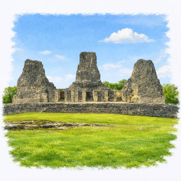
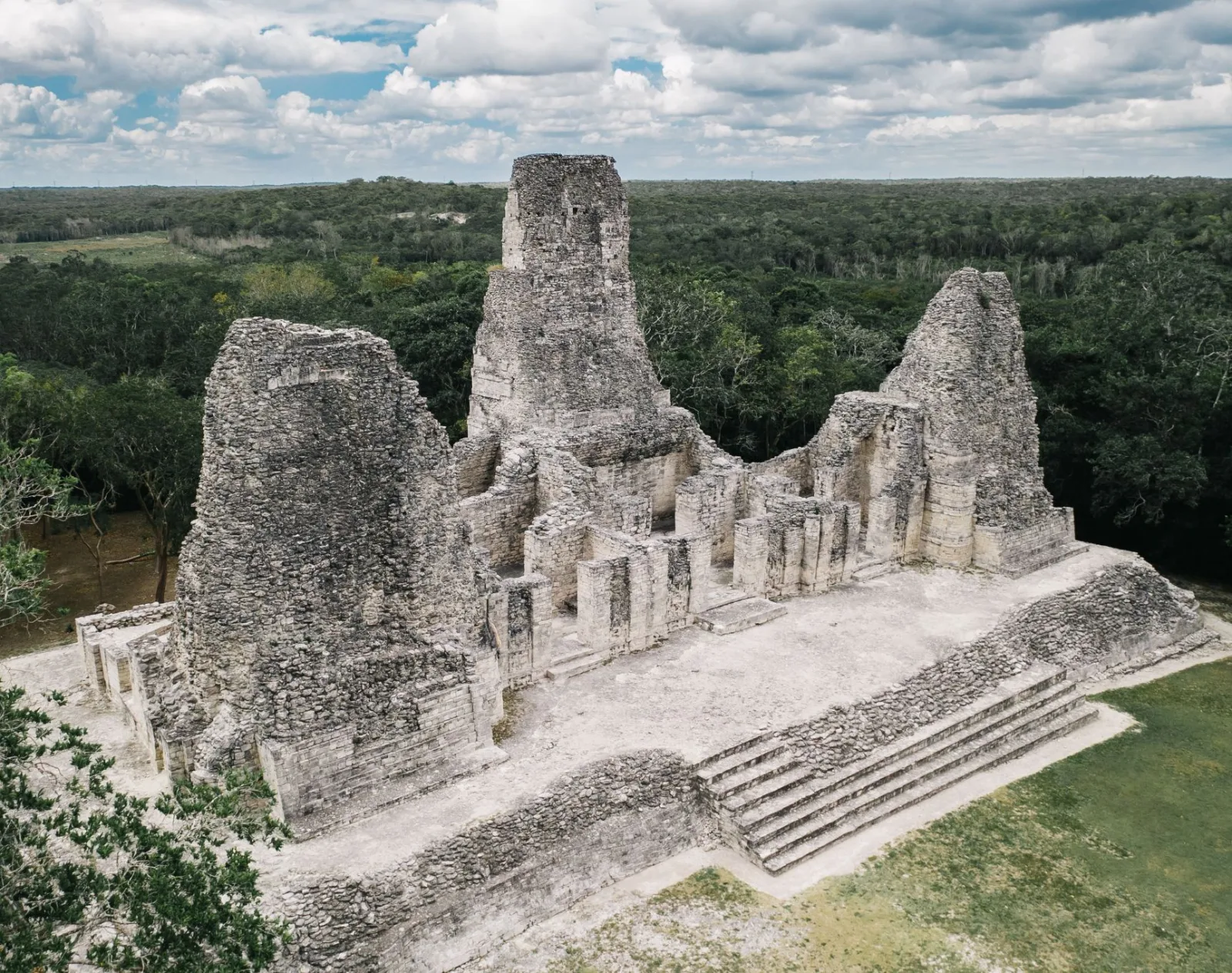
In the Río Bec region of Campeche, Xpuhil organizes broad palace ranges beneath narrow temple-crowned towers, creating one of the Maya lowlands’ most distinctive architectural profiles
| Name | Xpuhil |
| Civilization | Maya |
| Location | Río Bec Region, Calakmul Municipality, Campeche, Mexico |
| Elevation | 270 m (885 ft) above sea level |
| Years Active | 400 BCE to 1200 CE |
| Primary Resources | Limestone, lime plaster, stored rainwater, agricultural goods |
| Site Type | Elite residential and administrative center |
| Key Highlights | Building of the Three Towers, Río Bec architecture, serpent-mask doorways |
| INT Airport | Chetumal International Airport (CTM) |
| Entry Fee | 80 MXN national or resident; 145 MXN foreign visitor |
| Best Time to Visit | Morning or late afternoon |
| Field Visit | Visited and documented by Lost Ruins of the Americas |
Unique Features of the Xpuhil Ruins Archaeological Site
- Tripartite Tower Temple: Structure I features three false towers, an uncommon variation in Rio Bec architecture.
- Compact Scale: The core can be explored quickly, with concentrated detail in a small footprint.
- Stylized Upper Tiers: Decorative solid masses replace usable rooms, emphasizing form over function.
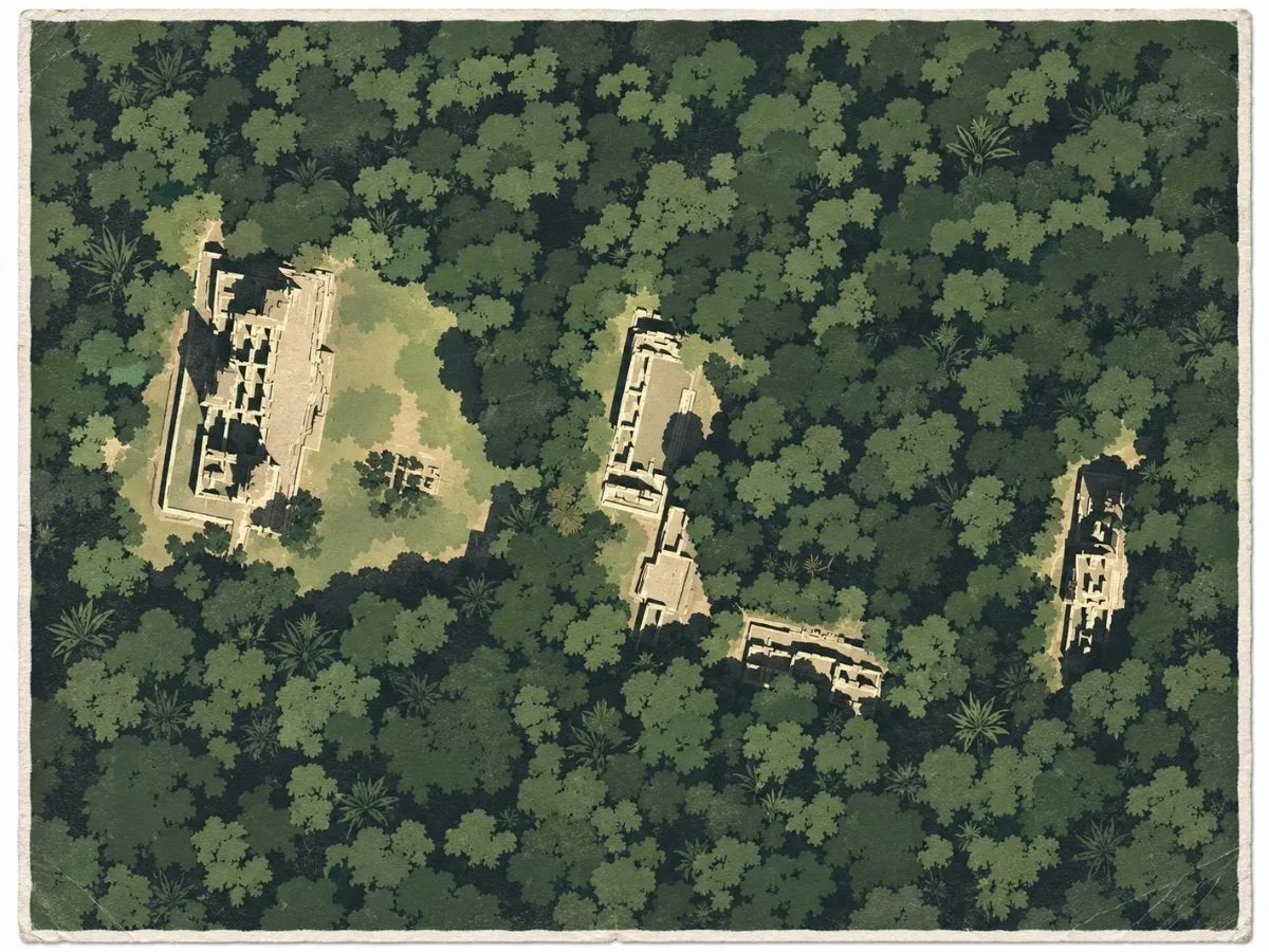
- Mixed Layout: Includes a tower temple, platform complex, and smaller auxiliary mounds.
- Regional Hub: Positioned near several major Rio Bec and Calakmul-area sites.
Location & Access
- Nearest Town: Xpujil, Campeche
- Directions: Chetumal, follow Federal Highway 186 west for approximately 120 kilometers to Xpujil. Site is walkable (~1 km) from town center
- Official Website: INAH Zona Arqueológica de Xpuhil.
- Opening Hours: 8:00 AM to 5:00 PM, with last access at 4:45 PM.
- Entry Fees: 80 MXN national or resident; 145 MXN foreign visitor
- Facilities: Minimal; no restrooms or vendors on site
- Accessibility: Limited. The public route includes uneven ground, exposed paths, low platforms, and stone steps around the principal structures.
- Pro Tip: Bring snacks and water and enjoy a quiet picnic near the base of the tower temple
Highlights to Help Understand Your Visit
Understanding Xpuhil becomes easier when you know what its towers and platforms were built to signal rather than to use.
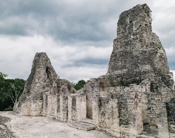
- A landscape shaped by impressions: The structures sit on gentle rises above the forest margin, giving the site more visual authority than its actual size would suggest. This positioning is intentional and helps you sense how presence was engineered.
- Attention guided upward: The towers and upper tiers draw the gaze vertically, encouraging visitors to read height as a marker of status. This upward emphasis reveals a community focused on visibility rather than interior space.
- Movement defined by narrow approaches: The paths between buildings create controlled lines of sight. They guide you toward specific facades, hinting that processional routes mattered for how people experienced ritual space.
- Gaps that speak to a dispersed community: The distance between the structures is unusual for a ceremonial core. These intervals show that Xpuhil was part of a scattered settlement network, not a dense urban center.
- Architecture meant to be read from the outside: Many features at Xpuhil make the most sense when viewed as external messages. The buildings communicate status and identity through form, posture, and placement rather than through interior complexity.
Key Structures of the Xpuhil Ruins
- Structure I: The most iconic building at Xpuhil, distinguished by its unusual three-tower design, a rare feature in Maya architecture. The central and flanking towers rise steeply with narrow stairways, and the upper tiers display the decorative flourishes of the Río Bec style. The structure likely served both ceremonial and symbolic functions, projecting power through its towering silhouette.
- Structure II: A broad platform and plaza complex situated opposite Structure I. Archaeologists interpret it as a space for smaller rituals or community gatherings, providing an architectural balance to the tri-towered temple. Its layout suggests processional use, reinforcing the ceremonial axis of the site.
- Structure III: A more modest temple-mound located apart from the central group, perhaps functioning as a support building or a localized shrine. Though less elaborate, its position shows how the site extended into the surrounding terrain.
- Structure IV: A rectangular palace-like building with multiple chambers, thought to have housed administrative or residential functions. Its doorway arrangements and alignment emphasize the practical side of life at Xpuhil, complementing the more theatrical structures nearby.
- Río Bec Features: Across the site, hallmarks of the Río Bec style are on display. False stairways, simulated upper temples, and decorative towers built more for visual impact than practical use. These features are emblematic of the region’s architectural experimentation in the Late Classic period.
- Pathways and Layout: Short trails connect the four main structures, winding through partially cleared jungle. This arrangement reflects the dispersed, non-urban pattern of many Río Bec centers, where ceremonial cores were surrounded by scattered habitation zones.
History and Legends
Across the low limestone ridges and seasonal wetlands of southern Campeche, Xpujil first developed around an aguada that supplied water in a landscape without permanent rivers. Early occupation reaches back to the Formative period, although the oldest known monumental buildings preserve stronger ties to the Petén tradition through vaulted substructures and ceramics found in Group XX. Agricultural terraces, reservoirs, and locally quarried limestone allowed the settlement to expand across the surrounding terrain rather than concentrate around a single civic center.
Xpujil reached its greatest development during the Late Classic period, when the architectural language now called Río Bec reshaped the community. At least two dozen building groups spread across the landscape, usually organized around open or enclosed patios. Vaulted rooms and raised benches point to elite residence, while the most prominent buildings also served political, administrative, and ceremonial purposes. Because no single core dominates the settlement, archaeologists have proposed that several noble houses controlled separate sectors while answering to the greater regional authority of Becán. Xpujil may therefore have functioned as an administrative subcenter within a network connecting communities between the Caribbean coast and the Laguna de Términos.
Experiences Around Xpujil
The ruins are only part of the story. Dense tropical forest surrounds this remote stretch of southern Campeche, with small Maya communities scattered along the highway.
–
At dusk, stop at Volcán de los Murciélagos to watch millions of bats spiral out of a deep forest sinkhole and stream across the evening sky.
–
North of town, La Mancolona offers guided jungle walks, marimba music, and regional cooking shaped by the community’s Tzeltal, Ch’ol, and Tzotzil roots.
That authority was expressed most clearly in Structure I, the Edificio de las Tres Torres. Built near the end of the Late Classic period, it departs from the usual Río Bec arrangement by raising three towers instead of two above a long range of rooms. The towers are solid, their stairways cannot be climbed, and the summit temples are largely simulated, turning the entire façade into an image of monumental pyramids rather than a group of functional sanctuaries. Cascades of serpent masks framed the entrances, while woven-mat symbols referred to political power. With no securely reconstructed dynasty or sequence of named rulers at Xpujil, architecture preserves the clearest surviving statement of how local elites presented sacred authority.
Regional cohesion weakened after the Terminal Classic period, and although occupation continued in parts of Xpujil, monumental construction eventually ceased. No genuine site-specific origin legend has been securely recorded. Instead, later memory survives in the name itself. Xpuhil means “place of the cattails,” recalling the plants that once grew around the aguada before modern development nearly erased it. Chicleros knew the ruins before Karl Ruppert and John Denison reported them during Carnegie Institution surveys in the 1930s, and the modern town later expanded across much of the ancient settlement. The group open today is therefore only one surviving fragment of a Maya community whose other compounds still lie among the streets and neighborhoods of present-day Xpujil.
How to Get There & Where to Go Next
How to Visit Xpuhil
– Step-by-step access to the site –
- Cancún to Xpujil Station Board the Tren Maya southbound toward Escárcega. Travel time about 5 to 6 hours.
- Station to Xpujil Town Take a local taxi along Highway 186 for 10 to 15 minutes into town.
- Town to Xpuhil Ruins Follow Highway 186 west for a 20 to 30 minute walk, or take a short colectivo or taxi ride.
- Road Access Option For drivers, use Highway 307 south from Cancún, then merge onto Highway 186 toward Xpujil. Total drive about 5 to 6 hours.
- Return Trip Taxis and colectivos run frequently along Highway 186 back toward the station.
Tips: Check the official site for seasonal hours; plan to combine your visit with the on-site museum for full contex.
Nearby Ruins You Can Visit
These nearby Maya sites share the same forested landscape and architectural traditions that shaped Xpuhil and the wider Rio Bec region.

Balamkú – Known for its rare stucco frieze with preserved paint and powerful royal imagery.
Chicanná – A compact elite compound known for its monster mouth façade and refined Río Bec stonework.

Calakmul – A vast Maya Capital with monumental pyramids and royal tombs hidden deep in the Calakmul Biosphere Reserve
Traveler Tips
- You can walk to Xpuhil from town in about 15 minutes. Taxis and colectivos are also available.
- There are no on-site vendors or shade, so bring snacks and water.
- The site is free to enter and rarely crowded.
- Avoid midday heat if possible. Early morning is ideal for cooler temperatures and softer light.
- The tower structure is visible from the road. A great photo spot even before entering.
Elsewhere in the Americas…
While Xpuhil’s builders shaped ceremonial towers in the forests of Campeche, powerful cultures across the Andes were developing their own traditions and regional networks.


Batán Grande marked the rise of early Sicán authority, with ceremonial precincts and elite tombs on Peru’s north coast.

The Ancestral Puebloans shaped life at Mesa Verde through cliff dwellings, masonry villages, and ceremonial kivas.
Insider Explorer Advice
Base yourself in Xpujil if you want to explore the region slowly and on your own terms. Unlike the deeper jungle sites, Xpuhil can be visited on foot and offers immediate reward. Bring a breakfast snack, find a shady spot, and take your time walking around the towers. The visual style is unlike anything else in the Maya world. Don’t rush it just because it’s small. The detail is in the stone itself.
Summary: Xpuhil is a compact vision of Maya geometry. Peaceful, iconic, and just steps from the modern road.