
Xunantunich
BELIZE / CAYO / MAYA
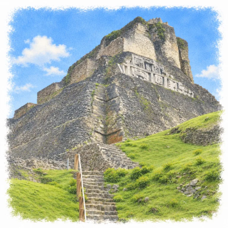
Above the Mopan River valley, Xunantunich crowns a limestone ridge with El Castillo, where monumental stucco friezes overlook the plazas and palaces of a Maya political center.
| Name | Xunantunich |
| Civilization | Maya |
| Location | San José Succotz, Cayo District, Belize |
| Elevation | Approximately 180 m / 590 ft |
| Years Active | Earlier settlement; principal center c. 600–900 CE |
| Primary Resources | Limestone, fertile valley soils, and river trade |
| Site Type | Hilltop ceremonial and political center |
| Key Highlights | El Castillo, stucco friezes, Plaza A-I, royal palace, Structure A9 |
| INT Airport | Philip S. W. Goldson International Airport (BZE) |
| Entry Fee | BZ$10 resident adult; BZ$25 non-resident adult |
| Best Time to Visit | Early morning; drier months from December to April |
| Field Visit | Visited and documented by Lost Ruins of the Americas |
Unique Features of the Xunantunich Ruins
- El Castillo: A temple-and-palace complex rises roughly 40 meters above the plaza.
- Stucco friezes: Monumental modeled figures cover the upper building’s east and west sides.
- River approach: A hand-cranked ferry crosses the Mopan below the archaeological reserve.
- Royal burial: Structure A9 was built around a large elite tomb.
- Traveled inscriptions: Reused panels connect the site with Naranjo and Caracol.
Location & Access
- Nearest Town: San José Succotz; San Ignacio is the main visitor base.
- Directions: Cross the Mopan River at Succotz, then follow the uphill access road for about 1.6 km.
- Official Website: NICH Xunantunich Archaeological Reserve.
- Opening Hours: Daily, 8:00 AM–5:00 PM. Last admission is 4:00 PM by vehicle or 3:30 PM on foot.
- Entry Fees: BZ$10 resident adult; BZ$25 non-resident adult. Ferry crossing is free.
- Facilities: Visitor center, restrooms, parking, picnic area, and local guides.
- Accessibility: An uphill approach, uneven ground, and steep monument stairs; upper structures are not wheelchair accessible.
- Pro Tip: Confirm ferry operation after heavy rain, when river conditions can interrupt access.
Highlights to Help Understand Your Visit
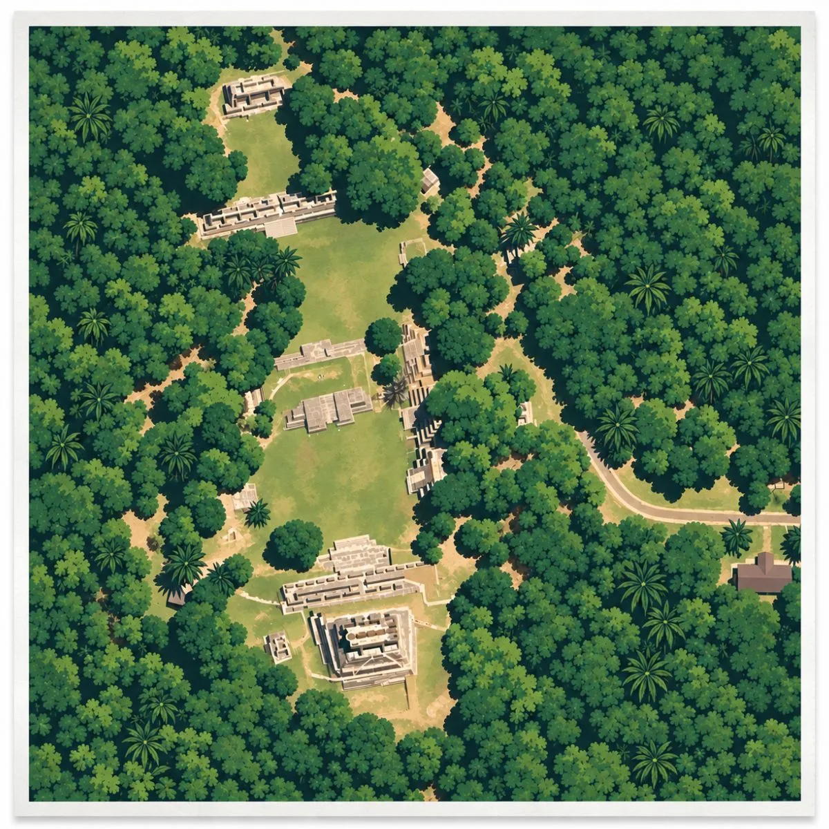
The broad plazas and restricted palace courtyards show how public ceremony and royal life occupied different parts of the same hilltop.
- Read the whole plaza: El Castillo dominates the view, but the buildings around the open ground give the center its scale. Their terraces framed gatherings and directed attention toward raised ceremonial spaces.
- Follow the changing access: Broad public areas lead toward smaller, elevated palace courtyards. Steps and narrow passages made approaching the ruling household a controlled movement through the city.
- Look across the friezes: Faces and supernatural figures form a continuous band around El Castillo’s upper building. The visible protective replicas help explain artwork whose original stucco remains sheltered beneath them.
- Connect hill and valley: The summit view takes in farmland and wooded ridges beyond the monumental core. The city’s position above the Mopan placed it beside a route linking inland communities with wider exchange networks.
Key Structures of Xunantunich
- El Castillo (Structure A6): The roughly 40-meter temple-and-palace complex anchors the southern side of the main plaza, with successive terraces and upper rooms overlooking the Mopan valley.
- East and West Friezes: Modeled stucco bands decorate El Castillo’s upper building with large masks and other supernatural imagery. Protective replicas preserve the appearance of the fragile original reliefs.
- Plaza A-I: The broad public space immediately north of El Castillo, framed by substantial platforms and buildings that make the scale of the ceremonial center apparent.
- Royal Palace (Plaza A-III): Structures A10, A11, A12, and A13 enclose an elevated courtyard at the northern end of the core. A11 contained a two-level arrangement of vaulted rooms associated with the ruling household.
- Structure A9: A pyramidal building containing a large burial chamber for an adult man, furnished with pottery and jade. Carved panels were placed beside its stairway; the sealed tomb is not a walk-in attraction.
- Ballcourts 1 and 2: Two courts differ in size and construction. The smaller court contained numerous buried offerings, while the larger court included stone rings and architectural influences from beyond the valley.
History and Legends
The major expansion of Xunantunich began after about 600 CE, when builders transformed an already occupied ridge above the Mopan River into a substantial political center. The river connected productive farmland with routes between the Caribbean coast and the kingdoms of the interior. During the following generations, construction spread across the hilltop, creating the plazas, temples, and palace compounds that dominate the site today. Xunantunich developed within a valley where older centers already held influence, making its rapid growth a significant change in the region’s political geography.
Connections with Naranjo, across the modern border in Guatemala, helped shape that development, although the precise relationship between the two courts remains debated. Carved panels placed beside Structure A9 provide a physical connection with the conflicts of larger kingdoms. They belonged to a hieroglyphic stairway associated with Caracol’s ruler K’an II, portions of which were dispersed to other sites. The stairway is thought to have been dismantled following Caracol’s defeat by Naranjo in 680. Some fragments eventually reached Xunantunich, bringing inscriptions about distant rulers into its ceremonial center. Their exact route and circumstances of arrival remain uncertain.
Structure A9 enclosed a large burial chamber as part of its original construction. Jade beads, ceramic vessels, obsidian blades, and shell ornaments accompanied the occupant, indicating considerable status without establishing a known royal identity. The tomb made burial central to the building’s purpose. Elsewhere, El Castillo combined elevated rooms, temples, and terraces above the principal plazas. Its elaborate stucco friezes depicted supernatural beings and celestial imagery, placing religious symbolism prominently on the architecture overlooking public gatherings.
At the northern end of the center, the palace around Plaza A-III controlled access through raised courts, passages, and vaulted rooms. Structure A11 included two levels from its initial construction, separating activities within the compound. Later changes closed entrances and made approaches more restricted. Public ceremony also occupied the city’s two ballcourts, which differed in form and history. The smaller court contained buried offerings associated with a local ceremonial tradition; the larger, later court incorporated stone rings and architectural features with parallels beyond the Belize Valley.
The palace compound was deliberately dismantled and filled before political authority disappeared from Xunantunich. Leaders continued commissioning carved monuments during the ninth century, even as construction diminished and the occupied settlement contracted. The regional center ceased functioning around the late ninth or early tenth century. Material deposited after some buildings had already deteriorated indicates continued activity or later returns, so the closing of the principal buildings cannot be treated as the departure of every inhabitant. The ruling center and the communities around it changed at different rates.
Experiences Around Xunantunich
The ruins are only part of the story. Around Succotz and San Ignacio, the Mopan and Macal rivers run between wooded hills, village gardens, and cultivated valley land.
–
On Saturdays, San Ignacio Market fills with produce from surrounding villages. Stop for tamales or pupusas among the fruit stalls near the Macal River.
–
At Belize Botanic Gardens, walk the plant collections or join a guided medicinal-plant tour, with native orchids, palms, and tropical fruit trees along the trails.
How to Get There & Where to Go Next
How to Visit Xunantunich
From Philip S. W. Goldson International Airport:
- Airport to San Ignacio: Take bus, or a prearranged shuttle or rental car west via the George Price Highway, about 2–2.5 hours.
- San Ignacio to Succotz: Continue by bus, taxi, or car to the ferry landing, about 20 minutes.
- Across the Mopan: Take the hand-cranked vehicle ferry; passengers cross outside the vehicle.
- Ferry to entrance: Continue uphill by road, about 5 minutes driving or 25–30 minutes walking.
Tip: Arrange the return pickup before crossing if arriving by taxi.
Nearby Ruins You Can Visit
Across Belize and the neighboring Maya lowlands, forest cities preserve the palaces, temples, and royal monuments of competing kingdoms.


Traveler Tips
- El Castillo stairs: Wear shoes with grip and follow the marked ascent; wet stone can be slippery.
- Open plazas: Carry water and sun protection for the exposed spaces between buildings.
- Time on site: Allow about two hours for the main plazas, palace, and El Castillo, plus the approach.
Elsewhere in the Americas
While Xunantunich’s rulers expanded their hilltop center, South American societies were building highland compounds, monumental courts, and elaborate burial grounds.

In Peru’s northern highlands, the Wari laid out Viracochapampa with straight passages and enclosed compounds, extending a planned architectural tradition into the country around Huamachuco.
Near Lake Titicaca, Tiwanaku formed the capital of the Tiwanaku civilization, with sunken courts, monumental gateways, and carved stone figures arranged within its ceremonial center.
On Peru’s central coast, the Lima culture raised Huaca Pucllana from rows of small upright adobe bricks, creating a massive ceremonial platform with plazas and courtyards in what is now Miraflores.
Insider Explorer Advice
From San Ignacio, take a local bus toward Benque Viejo and get off at San José Succotz. The hand-cranked ferry across the Mopan River makes a memorable start, often with other travelers heading to the ruins alongside you. From the far bank, walk uphill to the entrance. Before climbing El Castillo, spend some time in the main plaza. Its size and the substantial buildings surrounding it make clear how much there is beyond the pyramid. After the climb, continue toward the northern palace, where smaller courtyards and rooms offer a closer look at the spaces used by the city’s ruling household.
Summary: Xunantunich brings the scale of Maya public ceremony and the restricted spaces of royal life together on a ridge above the Mopan River.