
El Rey
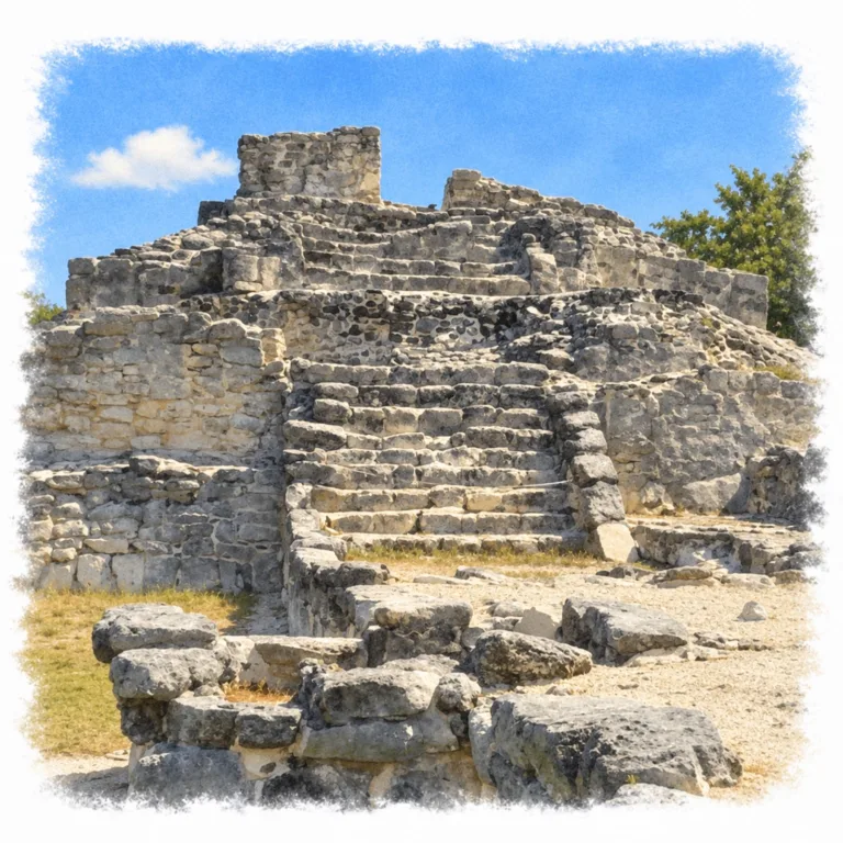
Between the Caribbean and Nichupté Lagoon, El Rey preserves a Maya coastal settlement where a long causeway links temple platforms, plazas, and colonnaded halls inside Cancún’s Hotel Zone.
| Name | El Rey |
| Civilization | Maya |
| Location | Cancún, Quintana Roo, Mexico |
| Elevation | Near sea level |
| Years Active | c. 300–1550 CE; principal growth in the Late Postclassic |
| Primary Resources | Fishing, salt, and maritime trade |
| Site Type | Coastal settlement and ceremonial center |
| Key Highlights | Structure 2, colonnaded halls, main causeway |
| INT Airport | Cancún International Airport (CUN) |
| Entry Fee | MX$80 Mexican visitors and residents; MX$145 foreign visitors. |
| Best Time to Visit | Early morning; cooler months from November to April |
| Field Visit | Visited and documented by Lost Ruins of the Americas |
Unique Features of the El Rey Archaeological Site
- Hotel Zone setting: Maya ruins surrounded by modern Cancún.
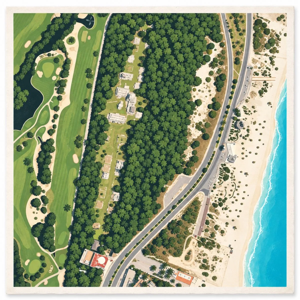
- Linear settlement: A central causeway joins two small plazas.
- Columned halls: Broad galleries once carried flat roofs.
- Painted palace: Surviving mural traces preserve part of the settlement’s religious imagery.
- Coastal connections: El Rey and San Miguelito likely belonged to one settlement.
Location & Access
- Nearest Town: Cancún, Mexico
- Directions: Boulevard Kukulcán, Km 18, on the lagoon side of the Hotel Zone near Playa Delfines.
- Official Website: INAH Zona Arqueológica de El Rey
- Opening Hours: Daily, 8:00 AM–5:00 PM; last entry at 4:30 PM.
- Entry Fees: MX$80 Mexican visitors and residents; MX$145 foreign visitors.
- Facilities: Parking and toilets.
- Accessibility: Mostly level ground, with uneven paths and raised stone platforms.
- Pro Tip: Carry water; the open plazas have little shade.
Highlights to Help Understand Your Visit
El Rey is easiest to understand as a coastal neighborhood with a ceremonial core, rather than an isolated pyramid.
- Follow the street: Buildings face a shared causeway instead of gathering around one enormous monument. The repeated platforms make the settlement’s organization easier to read.
- Rebuild the roofs mentally: The surviving columns belonged to covered halls. Their open appearance today can hide how substantial these gathering spaces once were.
- Look beyond the pyramid: Low walls and platforms preserve the spaces around the ceremonial center, giving the site more depth than its tallest building alone suggests.
- Read the coastal setting: The strip of land between sea and lagoon supported fishing and exchange. The surrounding water helps explain why a settlement developed here.
Key Structures of El Rey
- Structure 2: The principal pyramid supports a temple with at least two building phases. A high-status burial contained a copper axe, a bracelet, and shell and bone ornaments.
- Structure 1: A long, columned building whose broad gallery once supported a flat roof. Its scale suggests a public or administrative role rather than an ordinary house.
- Structure 4: Another large colonnaded hall, associated with smaller adjoining buildings. Meetings among governing groups are one proposed use of these larger spaces.
- Building of the Paintings: A palace identified by surviving mural remains. Painted decoration once added color and religious imagery to architecture now seen mostly as bare stone.
- Main Causeway: The central route links the plazas and rows of residential platforms, giving the site its long, narrow plan.
- Plaza Principal: One of El Rey’s two small plazas, forming part of the settlement’s public core alongside its temple and larger halls.
History and Legends
Fishing brought an early Maya community to the narrow strip of land between the Caribbean and Nichupté Lagoon. Settlement at El Rey reaches back to around 300 CE, when small stone platforms supported houses of wood and palm. The water on either side was an economic resource, not simply a boundary. Fishing and salt extraction helped sustain the community and connected its inhabitants with settlements farther inland. The surviving ruins belong largely to a much later period, when coastal exchange gave this part of the Yucatán Peninsula greater importance.
During the Late Postclassic, roughly 1200–1550 CE, El Rey expanded into a settlement with temples, plazas, and substantial public buildings. Its relationship with nearby San Miguelito suggests that the two archaeological zones preserve parts of a single coastal community rather than entirely separate towns. The principal causeway organized movement through El Rey, with buildings extending along its sides and two small plazas interrupting the line of the street. This was a place of houses and daily activity as well as ceremony, part of the maritime network along the eastern coast of the peninsula.
The larger buildings reveal distinctions within that community. Structures 1 and 4 contained broad galleries whose columns supported flat roofs, spaces interpreted as possible administrative halls or meeting places for governing groups. Structure 2 raised a temple above the surrounding buildings. Beneath it, a high-status burial accompanied by a copper axe and ornaments of shell and bone provides another indication of social rank. Painted decoration also belonged to this world: palatial buildings retained traces of murals with religious imagery characteristic of the region’s late Maya architecture.
The name El Rey, meaning “The King,” comes from a carved stone head, not a surviving record naming the settlement’s ruler. Its elaborate headdress includes a fantastic creature that may refer to Itzamnaaj, a Maya creator deity. The figure appears to represent a person of high status, but neither that person’s identity nor the monument’s complete original form is established. The sculpture gave later visitors a memorable name for the ruins; it does not supply a known dynasty or a documented story about a particular king.
Spanish conquest in the sixteenth century disrupted the coastal system on which El Rey depended. As regional trade and political relationships broke down, the settlement lost its population, with inhabitants dispersing toward the interior. Its abandonment was part of that wider upheaval, rather than the much earlier decline associated with many Classic-period Maya cities. The causeway, halls, and temple ceased to serve a living coastal community, leaving the remains of a settlement whose prosperity had depended on connections beyond its own shoreline.
Experiences Around El Rey
The ruins are only part of the story. Nichupté’s mangroves spread behind the Hotel Zone, while the Caribbean runs along its narrow oceanfront.
–
A guided kayak trip through the lagoon’s mangrove channels brings the tangled roots, sheltered water, and birdlife into closer view.
–
Downtown at Parque de las Palapas, stop for an evening marquesita, a crisp rolled wafer commonly filled with salty shredded cheese and something sweet.
How to Get There & Where to Go Next
How to Visit El Rey
From Cancún International Airport:
- Airport to Hotel Zone: Take an authorized taxi or prebooked transfer toward Punta Nizuc and Boulevard Kukulcán.
- Continue to Km 18: Ask for Zona Arqueológica El Rey, roughly 20–30 minutes from the airport in light traffic.
- Enter on the lagoon side: The archaeological entrance is beside Boulevard Kukulcán, near Playa Delfines.
Tip: From a Hotel Zone hotel, a local bus or taxi avoids returning through downtown.
Nearby Ruins You Can Visit
San Miguelito and El Meco extend the coastal story around Cancún; Chichén Itzá is a longer inland day trip into a much larger Maya center.

San Miguelito – Set beneath trees beside the Maya Museum, its pyramid and Palace of Chaak preserve another part of the settlement that once extended through the Hotel Zone.
Chichén Itzá – Farther inland, El Castillo and extensive colonnaded courts anchor a monumental Maya center, offering a larger-scale contrast to the low coastal buildings around Cancún.

El Meco – North of central Cancún, El Castillo rises above a compact plaza, where columned buildings reveal the public core of another Maya settlement along the Caribbean coast.
Traveler Tips
- Start near opening: The exposed central route becomes hotter as the morning advances.
- Allow about an hour: The full causeway and smaller platforms deserve time beyond the main pyramid.
- Uneven footing: Firm shoes suit the rough paths and stone surfaces better than beach sandals.
Elsewhere in the Americas
During El Rey’s late coastal florescence, South American societies were shaping very different settlements, from desert capitals to towns high in the Andes.


High above the Urubamba River, the Inca built Machu Picchu in the fifteenth century, fitting agricultural terraces, carefully worked stone buildings, and ceremonial spaces onto a steep mountain ridge.

In Peru’s northern highlands, Kuélap remained a major Chachapoya center, with circular houses crowded above immense stone walls on a mountain overlooking the valleys of the eastern Andes.
Insider Explorer Advice
El Rey rewards a slower look than its roadside setting might suggest. Structure 2 is the obvious focal point, but following the causeway past the plazas and colonnaded buildings gives the settlement more substance than a quick stop at the pyramid. The modern surroundings are part of the experience. Thresorts and traffic remain close, yet the route through the ruins follows the shape of a much older community. Few Maya sites make the step between an ordinary city day and an archaeological visit so immediate.
Summary: El Rey preserves the temple, columned halls, and residential layout of a Maya coastal settlement within Cancún’s modern Hotel Zone.