
Cobá
MEXICO / QUINTANA ROO / MAYA
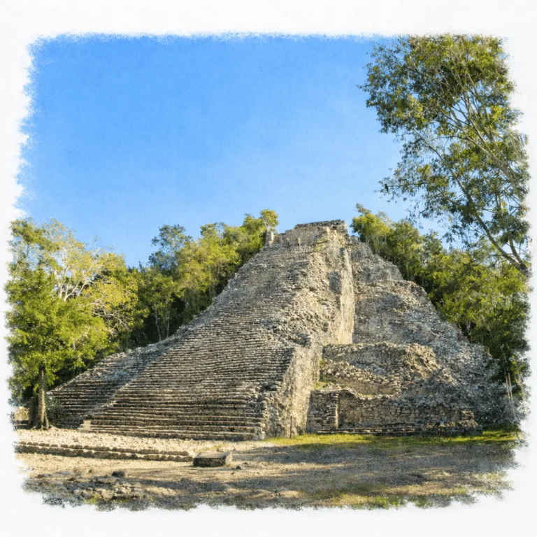
Amid dense jungle in the eastern Yucatán, Cobá extends a network of raised stone causeways, where long sacbeob connect distant groups across one of the most expansive Maya landscapes.
| Name | Cobá |
| Civilization | Maya |
| Location | Quintana Roo, Mexico |
| Elevation | 42 meters (138–140 feet) |
| Years Active | c. 100 – 1550 CE |
| Primary Resources | Limestone, freshwater lagoons |
| Site Type | Urban center with ceremonial causeways |
| Key Highlights | Nohoch Mul Pyramid, sacbé roads, jungle biking |
| Entry Fee | 105 MXN / 210 MXN |
| Best Time to Visit | Early morning to beat heat and crowds |
| Field Visit | Visited and documented by Lost Ruins of the Americas |
Unique Features of the Cobá Archaeological Site
- Bike Access: One of the only major Maya sites you can explore by bicycle. Rent onsite or hire a pedal taxi
- Nohoch Mul: One of the tallest pyramids in the Maya world at 42m (138 ft) tall
- Sacbé Network: Cobá is the nexus of over 50 ancient white roads, some stretching over 100 km
- Jungle Wildlife: Spider monkeys, toucans, and coatis move through the canopy and trails
- Less Touristed: Cobá feels wilder and more immersive than its coastal counterparts
Location & Access
- Nearest Town: Cobá, Quintana Roo. Tulum is the nearest major visitor base, about 47 kilometers away.
- Directions: From Tulum, follow Highway 109 northwest toward Nuevo Xcan. Public transportation also serves Cobá village.
- Official Site: INAH Zona Arqueológica de Cobá.
- Opening Hours: Daily, 8:00 AM to 5:00 PM. Last entry is at 4:00 PM.
- Entry Fees: 105 MXN for Mexican nationals and foreign residents; 210 MXN for foreign visitors.
- Facilities: Restrooms and basic visitor services near the entrance.
- Accessibility: Long distances and uneven stone paths limit access across parts of the site.
- Pro Tip: Nohoch Mul is currently open for climbing from 8:00 AM to 3:30 PM. Access is limited to groups of 15, with 15 minutes allowed at the summit, so reach the pyramid early in the visit.
Highlights to Help Understand Your Visit
Cobá is a site of distance, motion, and shifting power. These clues will help orient your walk:
- A City Measured in Roads: Cobá’s sacbé network wasn’t decoration it was communication. Every causeway you walk once led to another city. You’re standing in an ancient web of influence.
- Built for Expansion: Cobá didn’t grow around a central plaza. It stretched outward in clusters, each with temples and stelae. This reflects shifting alliances and political reach more than ritual unification.
- Jungle Coverage Is the Message: Much of Cobá remains buried under trees. That’s not neglect. It’s scale. The jungle shows how big this city once was, and how much is still unknown.
- Rulers in Stone, Not Thrones: The stelae at Cobá preserve images of women and men in power. Some wore jaguar pelts, others carried captives — look closely and you’ll see a city of dynasties.
- Climbing Was Participation: Nohoch Mul was climbable not for fun, but for function. Elite ceremonies happened at the top. That rope today is a ghost of the path ancient rulers once walked.
Key Structures of the Cobá Ruins
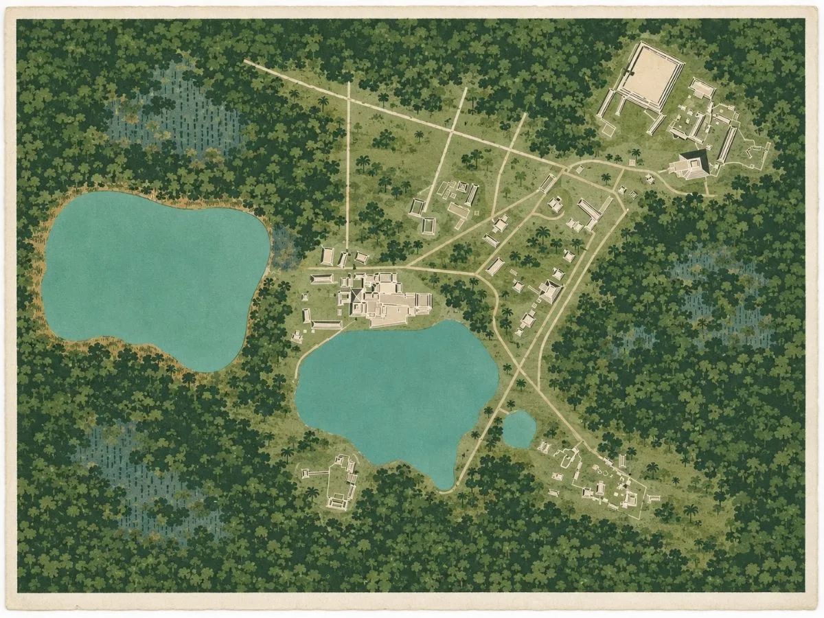
- Grupo Cobá: The oldest and most important explored sector, with more than 50 buildings arranged around plazas, patios, vaulted rooms, shrines, and a ballcourt. Six sacbeob extend from the group toward other parts of the city.
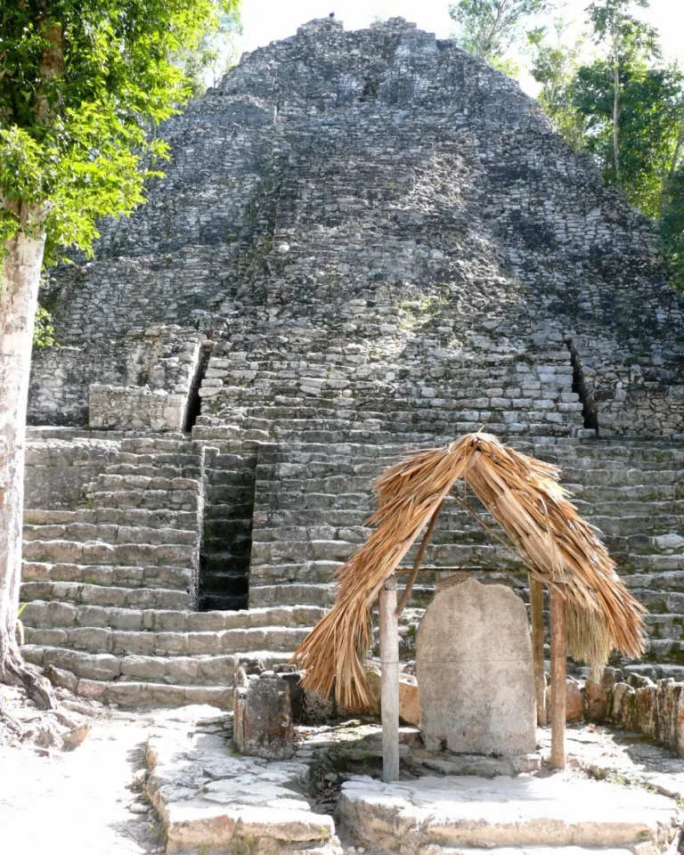
- La Iglesia: Cobá’s second-tallest building and one of the principal structures in Grupo Cobá. Its steep, weathered mass rises near the entrance, with Stela 11 standing at its base.
- Grupo Cobá Ballcourt: A compact court framed by sloping walls with carved captive panels embedded into both sides. The Kan Stairway rises directly behind it.
- Grupo D: A broad, more dispersed sector positioned between major sacbeob. Its plazas, ballcourt, painted temple, and rounded Xaibé structure reveal another important ceremonial center within the wider city.
- Conjunto de las Pinturas: A temple complex named for traces of mural painting preserved in its upper sanctuary. Later Postclassic construction rests over an earlier Classic-period building, leaving two phases of Cobá visible in one structure.
- Grupo D Ballcourt: Cobá’s second principal court, distinguished by carved captive panels and stone playing markers placed within the court.
- Xaibé: An unusual rounded, tiered structure standing near the junctions of several sacbeob. Its distinctive form sets it apart from the surrounding architecture, although its original purpose remains unknown.
- Grupo Nohoch Mul: A compact group containing the largest buildings by volume at Cobá. Its monumental structures gather around the towering pyramid and the broad plaza below.
- Nohoch Mul Pyramid: The tallest structure at Cobá, rising 42 meters above the forest. Seven rounded tiers support an upper temple, reached by two stairways on the front.
- Nohoch Mul Plaza and Stela: The broad plaza beneath the pyramid contains the best-preserved carved stela at Cobá, dated to 780 CE.
- Grupo Macanxoc: A ceremonial group reached by the city’s widest sacbé. Buildings, altars, and carved monuments stand across a broad artificial terrace.
- Macanxoc Stelae: Eight heavily weathered monuments preserve figures, captives, ceremonial bars, and glyphic inscriptions dating to the seventh century.
- Sacbé Network: Roughly 50 raised white roads connected Cobá’s ceremonial, residential, and administrative groups. The longest extended about 100 kilometers to Yaxuná, carrying the city’s reach far beyond its lakes.
History and Legends
Cobá began as small Maya farming and hunting communities beside the lakes of northeastern Yucatán during the first century BCE and the second century CE. In a limestone landscape where most water disappears underground, the lakes offered dependable surface water and a stable center for settlement. Cobá retained its ancient name in its inscriptions. It is commonly understood as “choppy water,” a reference to the lakes that shaped the city from its beginning.
Between the fifth and tenth centuries, Cobá grew into one of the major powers of the northern Maya lowlands. Monumental groups rose around plazas, temples, ballcourts, and carved stelae, while residential districts spread far beyond the lakes. At its Late Classic height, the city covered roughly 77 square kilometers and may have held between 60,000 and 90,000 people.
The sacbeob were central to that expansion. More than 50 raised white roads connected Cobá’s ceremonial, administrative, and residential districts, while longer routes reached communities beyond the city. Sacbé 1 extended nearly 100 kilometers west to Yaxuná, passing settlements and sources of water and building stone along the way. The roads supported movement, exchange, alliances, and political control, turning Cobá’s scattered districts into a connected capital.
Experiences Around Cobá
The ruins are only part of the story. Dense forest and freshwater cenotes shape this inland corner of northern Quintana Roo.
–
Cool off at Cenote Choo-Ha, descending into a limestone cavern filled with stalactites and clear blue water.
–
At nearby Punta Laguna, join a guided forest walk to look for spider and howler monkeys, then cross the lagoon by canoe.
Cobá’s inscriptions preserve a dynastic history in which women held unusual authority. The sixth-century ruler Ix Ch’ak Ch’een is named on the Roca de la Fundación and several related monuments. The texts connect her with an event in 569 involving Kehwitznal, apparently the ancient name of the Nohoch Mul group, and the establishment of the kaloomte’ office. Her name also appears on monuments associated with a new phase of the Group D ballcourt and a period-ending ceremony in 573.
A century later, Lady K’awiil Ajaw ruled from about 640 until 681 or 682. Her monuments show her standing above captives, using the visual language of military and political command normally associated with powerful Maya kings. Her reign coincided with a period of westward expansion, and scholars have proposed that Sacbé 1 was built or strengthened under her authority. The connection remains a strong possibility rather than a confirmed commissioning record.
Between 900 and 1000, Cobá competed with the rising power of Chichén Itzá and eventually lost its position at the center of regional politics. It remained active as a religious and commercial center, and Postclassic builders continued to reuse and alter older structures. By the time Spanish forces entered the Yucatán Peninsula, the city had been abandoned.
Water remained part of Cobá’s sacred identity as well as its survival. The Roca de la Fundación was carved beside an aguada near Nohoch Mul and names protective deities connected with the creation of the city. Its inscription also refers to the witz’ serpent, a being closely associated with bodies of water. The text preserves Cobá’s own sacred history, linking its rulers, its lakes, and the origin of the city within the same living landscape.
How to Get There & Where to Go Next
How to Visit Cobá
Step-by-step access to the site
- From Cancún: Drive or bus to Tulum, about 2 hours
- Tren Maya Option: Ride to Tulum station, then transfer to local colectivo
- Tulum to Cobá: Colectivos depart from ADO station, about 45 minutes
- Arrival: Drop-off point is a short walk from the entrance gate
- Onsite: Walk in or rent a bike, 5 to 10 minutes to reach major structures
Tip: Tren Maya routes are still expanding, check latest schedules. Bikes go fast on hot days, so arrive early for rental.
Nearby Ruins You Can Visit
These Maya sites are connected through raised causeways, forested ceremonial centers, and shifting regional power. Echoes of Cobá’s own complex legacy.


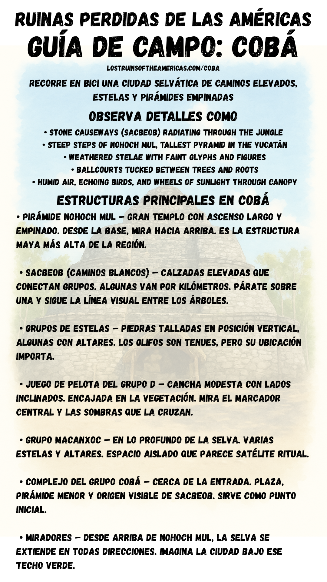
Download Quick Guide
Español
English
Traveler Tips
- Arrive when the site opens to beat heat and enjoy quieter paths
- Rent a bike or hire a tricycle taxi, the site is large and flat
- Bring water, sun protection, and insect repellent
- Combine with a cenote, options like Multum-Ha or Tamcach-Ha are nearby
- Pack a snack, there are no food vendors inside the site
Elsewhere in the Americas…
While Cobá’s pyramids rose in the Yucatán jungle, other cultures across the Americas were shaping regional power and identity:

Along Peru’s northern coast, Huaca de la Luna continued Moche ceremonial traditions even as political power shifted.
Insider Explorer Advice
Cobá is a breath of fresh air, literally and figuratively. The chance to bike from temple to stelae, with monkeys chattering overhead and few crowds around you, makes it a uniquely peaceful ruin experience. You’ll feel like you’re discovering it, not just visiting. Stop often. Let the forest settle around you. Don’t rush the sacbés. They are the soul of this site. Follow one out into the trees. Look for glyphs on stelae tucked under mossy palapas. And when you’re done, dive into a cenote to cool off and let the day soak in.
Summary: Cobá is wheels, trees, temples, and quiet. A jungle city made for exploring under your own power.