
Xochicalco
MEXICO / MORELOS / MULTI-ETHNIC
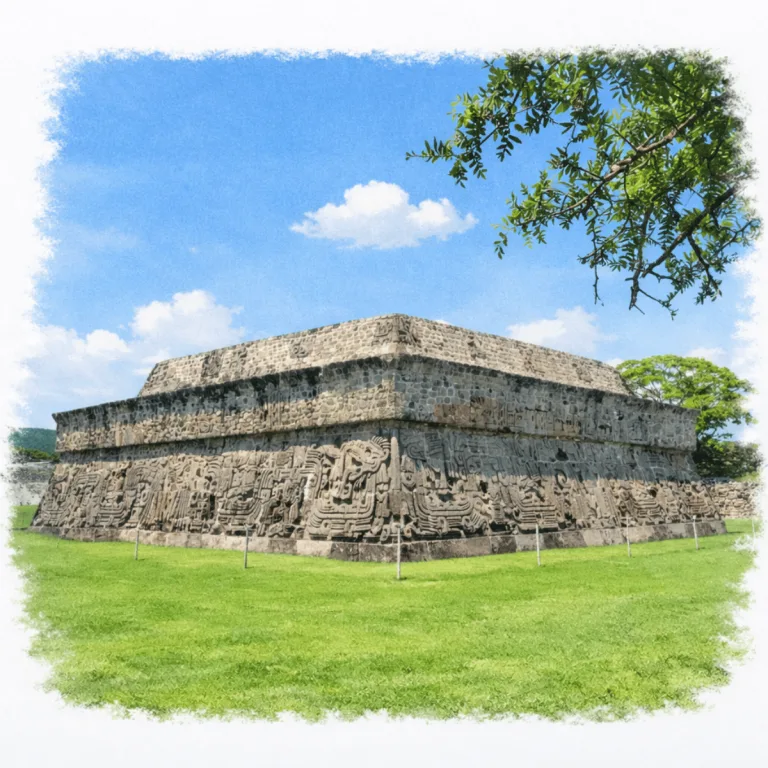
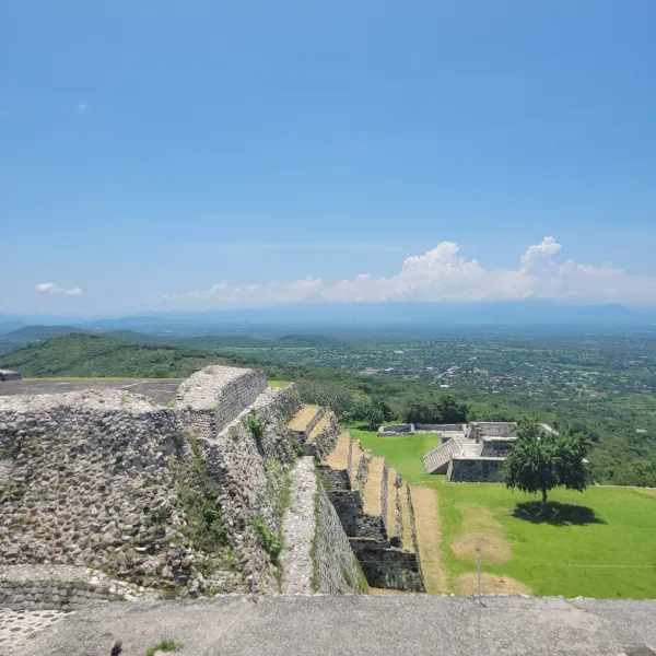
On a terraced hilltop above the Morelos valleys, Xochicalco organizes a fortified ceremonial city, where ramps, terraces, and massive retaining walls shape a settlement built for defense in an unstable era.
| Name | Xochicalco |
| Civilization | Multi-ethnic; primarily Nahua, influenced by Maya & Teotihuacan |
| Location | Miacatlán, Morelos, Mexico |
| Elevation | 1,300 to 1,500 m (4,200 to 4,900 ft) above sea level |
| Years Active | c. 200 BCE to 1000 CE; principal period 650 to 900 CE |
| Primary Resources | Volcanic stone, lime plaster, stored rainwater, regional trade goods |
| Site Type | Fortified hilltop city with ceremonial and civic structures |
| Key Highlights | Ballcourt with towering walls, Temple of the Feathered Serpent, astronomical observatory |
| INT Airport | Mexico City International Airport (MEX) |
| UNESCO | Archaeological Zone of Xochicalco |
| Entry Fee | 105 MXN national or resident; 210 MXN foreign visitor |
| Best Time to Visit | Dry season, November to April, weekday morning |
| Field Visit | Visited & photographed by Lost Ruins of the Americas |
Unique Features of the Xochicalco Archaeological Site
- Architectural Highlights: Temple of the Feathered Serpent, tiered plazas, elite residences
- Notable Artifacts: Maya-style reliefs, obsidian tools, observatory shaft
- Natural Surroundings: Panoramic views of the Morelos valley and surrounding volcanic ridges
- Comparative Notes: Strategically built with influences from multiple cultures, and fortified like no other site of its time
Location & Access
- Nearest City: Miacatlán, Morelos; Cuernavaca is the nearest major visitor base
- Directions: Buses to Xochicalco depart from the Terminal Lasser Mercado in Cuernavaca. The ride takes about an hour and drops visitors directly at the archaeological zone’s entrance. Return buses can be caught at the same stop, but schedules vary, check departure times in advance
- Official Website: INAH Zona Arqueológica de Xochicalco
- Opening Hours: 9:00 AM to 6:00 PM, with last access at 5:00 PM.
- Entry Fees: 105 MXN; 210 MXN for foreign visitors. Admission includes the site museum.
- Facilities: On-site restrooms, museum, shaded rest areas, QR-code signage.
- Accessibility: Partial. The museum and visitor facilities are accessible, but the archaeological route includes slopes, terraces, stone paving, ramps, and stairways
- Pro Tip: Visit Tuesday through Sunday and begin with the museum, which closes earlier than the archaeological zone.

Highlights to Help Understand Your Visit
Xochicalco is more than a fortified city. It is a blueprint of ambition, astronomy, and cultural fusion. These cues will help you read the site with sharper eyes:
- Built to Dazzle, Not Just Defend: The steep slopes and stone walls weren’t just for safety. They projected authority. This city was designed to be seen and obeyed.
- Everything Faces the Sky: From platform alignments to carved glyphs, Xochicalco’s builders encoded solar knowledge into the city’s bones. Notice the sun’s path across plazas and altars.
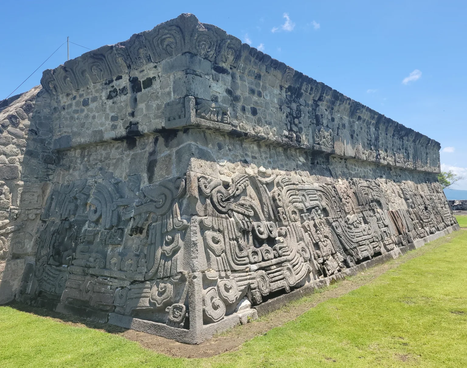
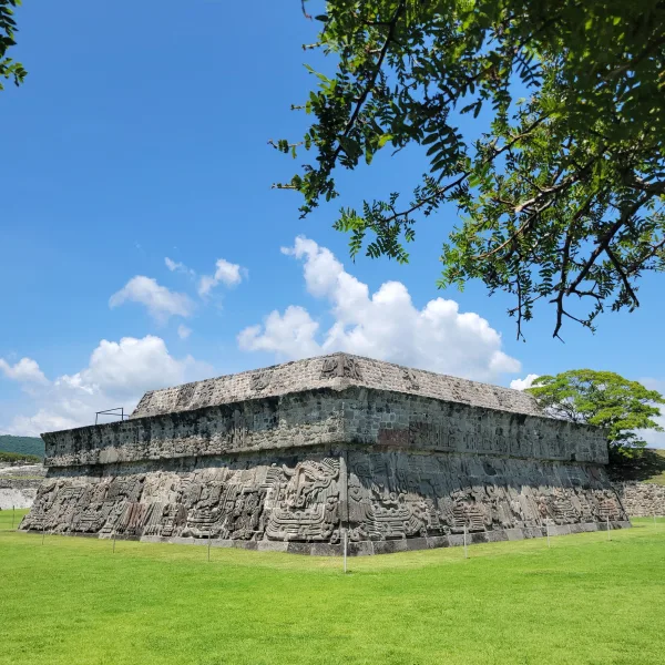
- Serpents Mean Power: The feathered serpents carved into the temple platform aren’t decorative. They mark ideology, cosmology, and elite rule, all tied to Quetzalcoatl.
- Movement Was Controlled: Tiered platforms, staircases, and bottleneck corridors directed how people moved. This reinforced hierarchy at every level.
- Not Just One Culture: Maya-style carvings, Teotihuacan-style architecture, and Zapotec-influenced layout show this was a city of intentional fusion, not chance diversity.
- The Observatory Is Real Science: The cave with a light shaft isn’t a myth. It still works. Priests used it to track the zenith sun, syncing human ceremony with cosmic rhythm.

Key Structures of Xochicalco
- Temple of the Feathered Serpent (Pirámide de Quetzalcóatl): Decorated with deep relief carvings of plumed serpents, seated figures, and glyphs, likely used for elite ritual and ideological display.
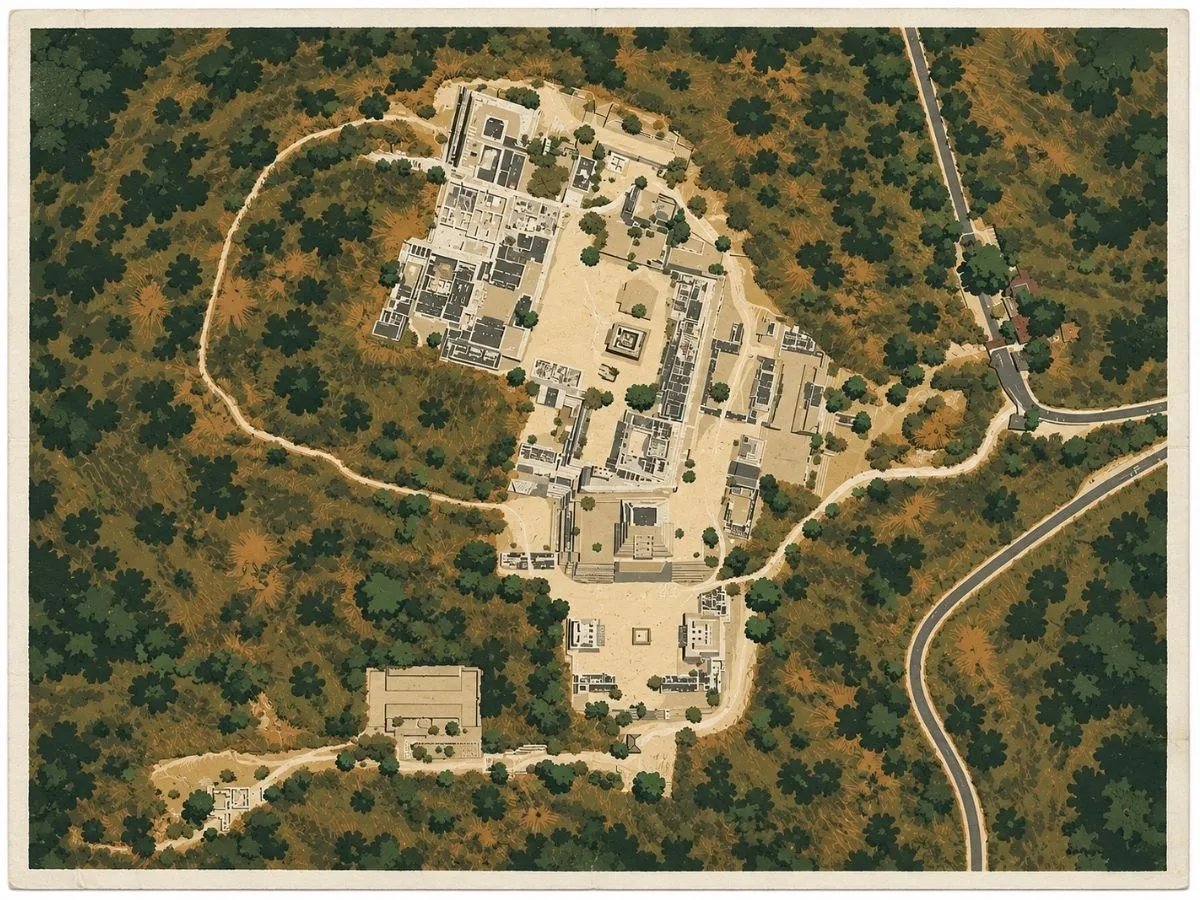
- Acropolis Complex: Elevated ceremonial and administrative zone.
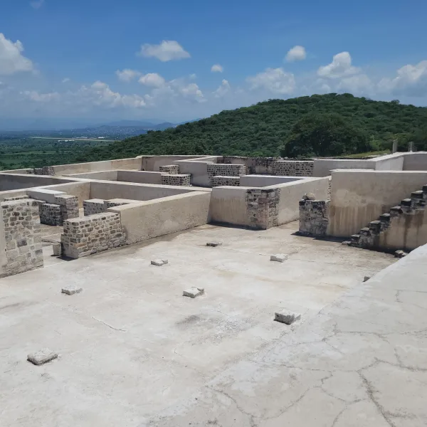
- Elite Residences: Multi-room buildings for ruling families and visiting dignitaries.
- Altars and Small Temples: Used for offerings, ritual gatherings, and regional ceremony.
- Discovery Site of “El Creador” Statue: This red sandstone sculpture, possibly representing a creator deity or dual cosmic force, was found here and is now displayed in the Xochicalco Site Museum.
- Plaza of the Two Glyphs: Ceremonial entry plaza aligned to the cardinal directions, featuring a carved stela with glyphs possibly marking the city’s founding and its dedication to Quetzalcoatl.
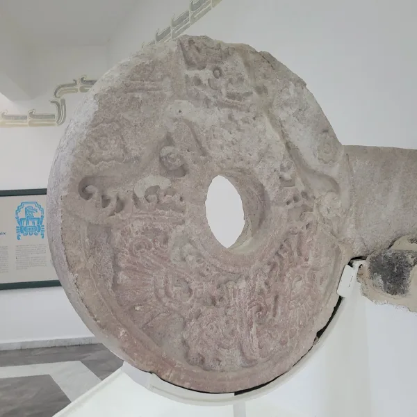
- Ballcourt: One of the tallest in Mesoamerica, this structure hosted ritual games with political and cosmological significance.
- Astronomical Observatory: Modified natural cave with a vertical shaft allowing sunlight to enter during zenith days, used for solar tracking and ceremonial timing.
- Platform of the Stelae: Raised area believed to host carved stone monuments commemorating rulers or cosmic events.
- Cisterns and Drainage Channels: Engineered water management system sustaining the hilltop population.
History and Legends
Xochicalco stands as a testament to the power vacuum left in central Mexico after the fall of Teotihuacan. Built around 650 AD on a defensible hilltop, this city quickly rose to prominence as both a trading hub and a ceremonial capital, attracting people, ideas, and architectural styles from across Mesoamerica.
Its name in Nahuatl means “Place of the House of Flowers,” but don’t be misled by the poetic flourish. Xochicalco was engineered for control. The site is enclosed by steep slopes, defensive walls, and tiered platforms designed to restrict movement and display power. While many cities in Mesoamerica relied on religious prestige or population size, Xochicalco projected strength through fortification and innovation.
At its peak, the city housed as many as 20,000 people. Archaeological evidence shows that its population was multi-ethnic, including Nahua, Zapotec, Maya, and other groups, and its architecture reflects this diversity. The most iconic structure, the Temple of the Feathered Serpent, features Maya-style relief carvings not commonly found this far west. The building is adorned with deeply incised depictions of feathered serpents, seated figures, and glyphs, suggesting a deliberate attempt to emulate Maya artistic and ideological prestige.
Below the temple lies a massive ballcourt, one of the most impressive in all of Mesoamerica. Its walls are high and steep, creating an intense, enclosed space for ritual games. Ballcourts were more than recreation. They were political and cosmological theaters. Victories could secure alliances; defeats might mean sacrifice.
The city’s layout reflects deliberate urban planning. Broad plazas, elite residences, altars, and observatories form a grid that channels both movement and meaning. A system of cisterns and underground drains shows advanced water management, essential for life on a hilltop with no natural springs.
Among Xochicalco’s most unique features is its astronomical cave observatory. This natural chamber was modified to allow a beam of sunlight to penetrate through a shaft at specific times of year, particularly during the zenith sun, when the sun passes directly overhead with no shadow. This knowledge allowed priests to track calendars, time agricultural cycles, and conduct rituals with cosmic precision.
Experiences Around Xochicalco
The ruins are only part of the story. Dry tropical forest and cultivated valleys cover the hills of southwest Morelos, with lakes and reservoirs scattered through the landscape.
At Laguna de Coatetelco, order mojarra fried or al ajillo, then spend some time along the lakeshore where fishing still shapes daily life.
In Cuernavaca, visit the Robert Brady Museum inside the Casa de la Torre, where rooms crowded with Mexican and international art open onto shaded courtyards and gardens.
Xochicalco’s rise, however, was also swift and short-lived. By around 900 AD, it was largely abandoned. Scholars believe this may have been due to internal rebellion, environmental stress, or shifts in trade routes. Unlike Monte Albán or Tenochtitlan, which left long political legacies, Xochicalco vanished almost as quickly as it appeared. It was a flash of urban brilliance extinguished by conflict or change.
Spanish chroniclers never recorded Xochicalco in active use, but legends persisted. Local Nahua communities spoke of ancient wisdom hidden in the hills, of star priests and buried gods. When the site was rediscovered in the 18th and 19th centuries, it captivated early archaeologists and later became one of the best-preserved examples of Epiclassic-period culture.
Today, the site is well-maintained, with a modern interpretive museum and QR-code signage that offers layered explanations at each building. The elevated views from the site’s highest platform stretch for miles, offering a true sense of Xochicalco’s strategic and symbolic reach.
For modern visitors, it’s not just the architecture that impresses. It’s the sense of intent. Xochicalco wasn’t built to last forever. It was built to dominate, to dazzle, and to align the heavens with the ambitions of a single city on a hill.
How to Get There & Where to Go Next
How to Visit Xochicalco
– Step-by-step access to the site –
- Start in Cuernavaca: Frequent service via regional bus terminals (~15 min to station).
- Take a bus to Xochicalco: Depart from Terminal Lasser Mercado; ride takes ~1 hour.
- Arrive at the entrance: Bus drops off directly at the site’s museum.
- Explore on foot: Expect moderate walking with stairs and exposed paths (~2–3 hours).
Tips: Visit on a weekday for fewer crowds. Scan QR codes at major sites for bilingual info. Check bus return times in advance.
Nearby Ruins You Can Visit
Xochicalco rose after Teotihuacan’s fall. It was a fortified experiment in trade, cosmology, and control. These nearby ruins echo its influences, rivals, and regional reach.

El Tlatoani – A little-known hilltop shrine near Tlayacapan, still shrouded in ritual and local legend.

Teotihuacan – Much older, but its sacred geometry and warrior symbolism helped shape the ideology of later Aztec sites like Malinalco
Chalcatzingo – A mountain-ringed site with Olmec-style carvings, rain god iconography, and early plaza planning rooted deep in Mexico’s highland past..

Traveler Tips
- What to Bring: Water, sun protection, a charged phone to use QR features, walking shoes
- Best Time to Visit: Mornings for cooler weather and museum access; avoid rainy season
- Nearby Attractions: Cuernavaca, El Tepozteco, Las Estacas eco-park
- Safety Notes: Sun exposure is strong and shade is limited on the upper levels
Elsewhere in the Americas…
As Xochicalco rose in central Mexico, other cultures across the Americas were also entering periods of change and expansion:
The Moche center of Huaca del Sol rose with massive adobe platforms and ceremonial architecture tied to elite power.


The Ancestral Puebloans built cliff dwellings and kivas at Mesa Verde, reflecting community life in the high desert.
Insider Explorer Advice
Xochicalco is among the most rewarding ruins in central Mexico for travelers who want a complete, self-contained experience. The bus from Cuernavaca is reliable and drops visitors directly at the entrance, where a clean, organized welcome center and museum provide orientation. The main paths are well-maintained, and the QR code signage allows deeper engagement with the site. The ballcourt is one of the tallest and most dramatic in Mesoamerica, and the upper platforms offer expansive views across the countryside. Visitors are encouraged to check return bus schedules in advance and allow time to explore the museum before leaving. This site offers not just ruins, but an immersive window into Epiclassic ambition.
Summary: Xochicalco rose fast and burned bright. It was a fortified, multi-cultural city where cosmology, trade, and power collided on the mountaintop.